
DAI Labs Publishes Paper on Near-Real-Time Forest Anomaly Detection Using Sentinel-1 SAR Data
The need to understand forest conditions quickly and continuously is growing rapidly, driven by efforts to prevent illegal logging, ensure supply chain transparency, manage land use appropriately, and meet carbon market standards.
The DAI Labs research team (Pann Thinzar Seint, Subas Chhatkuli, and Bryan Atwood) has published a paper on a “two-stage statistics-encoder cascade” method. It combines synthetic aperture radar (SAR) data from the European Space Agency’s (ESA) Sentinel-1 satellites with AI to detect forest changes and anomalies in near real time. By using SAR data, which is less affected by clouds and weather, the method aims to enable early detection of deforestation. (arXiv)
In this post, we introduce the key points of the technology presented in the paper and its potential social value.
1. Why is this technology needed? Challenges in forest monitoring
Detecting forest changes such as illegal logging early, and preventing further damage, requires rapid and continuous monitoring. However, conventional satellite observation faces two main challenges.
Optical satellites: limited by cloud cover
Optical satellites, which capture images of the ground like a camera, cannot see the surface when clouds block the view. In cloud-covered tropical regions, it can be difficult to monitor forest changes continuously.
SAR satellites: false detections of deforestation
SAR satellites, which use radar, are less affected by clouds and by day or night. However, changes in soil moisture between the rainy and dry seasons, along with other seasonal variation, also affect the observation data. As a result, these changes can be mistaken for deforestation, causing false alarms.
2. DAI Labs’ solution: a two-stage detection technique combining statistical analysis and AI
DAI Labs has proposed a “two-stage cascade” method that combines statistical analysis with AI (deep learning) to detect forest changes from SAR satellite data.
The method first uses statistical analysis to extract candidate changes, then uses AI to verify those candidates. By making a staged decision with two different approaches, it aims to capture forest changes while reducing false detections caused by natural environmental variation.
Detecting forest changes in two stages
1. Statistical analysis: extracting candidate changes. Sentinel-1 observations are compared with past data from the same season, and areas where the radar response shows a statistically significant change are extracted.
2. AI analysis: verifying candidate changes. An AI model (a convolutional autoencoder) trained on stable forest data further verifies the extracted candidates. An anomaly alert is issued only when both the statistical analysis and the AI analysis confirm a change.
How it works
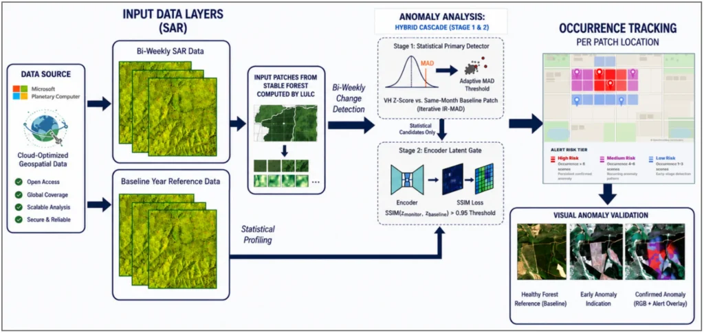
Figure: The overall flow of the system, from satellite data through two stages of statistical and AI processing to alert output.
Example results
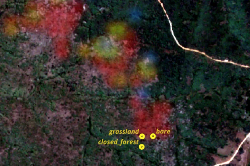
Low risk is shown in blue, medium risk in purple, and high risk in red.
Figure: Example of field verification in Malawi (conducted in October 2025). Active logging points confirmed in the field (GPS data) match the alert areas automatically detected by the system.
What makes it stand out
- Less affected by weather and time of day: Whether it is cloudy or night, forest changes can be detected at intervals of one to two weeks.
- Fewer false detections: Reduces false detections caused by rain and seasonal change.
- Explainable results: Because “why this location looks suspicious” is backed by numbers and data, the results are convincing and transparent even to third parties.
3. How does it help the world? Social value
Enabling rapid response to illegal logging
Within days of trees being cut, you can see where and how much area has been cleared, so you can respond quickly before the damage grows. It also helps with planning patrols that keep field staff safe.
Contributing to climate action (carbon trading and environmental protection)
It can serve as information that supports verification of how much forest has been destroyed and how much is growing, which contributes significantly to evaluating forest protection projects and CO2 reduction.
Demonstrating responsible sourcing for companies
It can be used as a means to demonstrate that a company’s products, such as timber and agricultural goods, were not produced by illegally clearing forest.
Beyond forests
The core idea behind this method, comparing current observations with a past stable state to detect change, can also be applied to challenges beyond deforestation.
- Understanding flood and inundation: Taking advantage of SAR’s ability to see through clouds, map the extent of flooding over wide areas.
- Detecting illegal and small-scale mining: Capture land changes in forests and along rivers to identify signs of mining activity.
- Monitoring agricultural expansion and infrastructure development: Detect road construction and land-use changes in protected areas.
4. Start a new project with DAI Labs: seeking partners
DAI Labs is looking for collaboration partners and adopting companies who want to use this technology to solve social challenges and create new business value.
We welcome inquiries such as:
- Carbon offsets and climate finance (MRV): Accurate monitoring, reporting, and verification of carbon credits, including REDD+ and voluntary credits.
- ESG management and supply chain management: Demonstrating that sourced raw materials (timber, agricultural products, and so on) are not linked to deforestation, and ensuring traceability. Understanding environmental risk based on data.
- Disaster prevention and response: Early understanding of wide-area flooding during heavy rain and floods.
- Environmental governance and government: Early detection of illegal logging and incursions into protected areas, and more efficient field patrols.
- New business and joint research: Companies and organizations considering new services using satellite data and AI, or proof-of-concept (PoC) trials.
For technical details, quotes, or proof-of-concept consultations, please feel free to contact us. Our specialists will guide you carefully.
Contact Form: DAI Labs Contact Page
Email: [email protected]